.png)

When Going Viral Damages Public Lands: What Boynton Canyon’s “Subway Cave” Teaches Us About Fragile Places, Foot Traffic, and Responsibility
- Ashley Goes Hiking

- Nov 20, 2025
- 13 min read

For most people, visiting public lands feels simple: you find a trail online, you head out, and you enjoy the scenery. But the last decade of recreation science research makes one thing very clear: not every place can handle heavy foot traffic, and once fragile ecosystems or cultural sites are damaged, the harm is often irreversible.
This is not a hypothetical problem. Sedona’s Boynton Canyon is a real time example of what happens when a once quiet trail suddenly goes viral.

I’ve been wanting to talk about this issue for years, and finally feel like I’m far enough removed from the initial anger and sadness I felt when this place was damaged, so today I am finally breaking down why some places truly cannot sustain mass visitation, and use the history of the so called Subway Cave to show what happens when online exposure outpaces what the land can handle.
But, before I tell the story of geotagging impacts, let’s get some background underway about recreation ecology and trails.
Why Some Public Land Sites Cannot Handle Heavy Foot Traffic
Recreation ecology, the field that studies how hiking and outdoor recreation affect natural ecosystems, has decades of data showing that fragile environments suffer rapid, sometimes permanent, damage when visitation spikes.
Here is what the science tells us:
1. Fragile soils and crusts are easily destroyed
Alpine tundra, desert cryptobiotic soil, and delicate sedimentary formations can be damaged with just a few footprints. Recovery can take decades, if it happens at all. Research shows that recreational trampling reduces vegetation cover, decreases plant height and seed production, alters soil structure, and increases erosion rates.

Cryptobiotic soil and lichen in Sedona.
2. Vegetation loss leads to erosion
Once plants are trampled, soil becomes loose, runoff increases, and entire slopes begin to erode. After vegetation is damaged, ecosystems rarely return to their original state without intervention.

Image from Boynton Canyon showing 2 year changes from visitation.
3. Social trails multiply impact exponentially
When large groups seek unmarked or unofficial features, especially scenic Instagram spots, they quickly create social trails that cut through fragile areas. These trails widen dramatically, fragment habitat, damage plant root systems, and increase runoff and erosion
Studies show that informal or unofficial trail networks are strongly associated with rapid vegetation loss and surface soil exposure.
4. Cultural sites are especially vulnerable
Archaeological dwellings, rock art, and artifacts are incredibly delicate. Foot traffic, touching, climbing, leaning, and even humidity from crowds can accelerate decay. Once a wall collapses, there is no restoring it to its original cultural integrity.
This deterioration happens even faster when people lean up on or touch dwelling sites or rock art, like below.

Boynton Canyon is one of the clearest examples of this entire cycle happening in real time.
Official Trails Versus Unofficial Trails
Understanding the difference between official and unofficial trails is essential for responsible recreation and is a key piece of information as it relates to what happened at Boynton Canyon.
Official Trails
An official trail is created, approved, routed, and maintained by a land management agency such as:
National Park Service
U.S. Forest Service
Bureau of Land Management
State Parks
Tribal Nations

Screenshot from official trail map of Coconino National Forest, above. You can see the official trail does not go to the “Subway Cave”.
Official trails are intentionally placed in areas that can withstand foot traffic and are engineered with drainage, erosion control, and hardened surfaces.
You can find official trail information on:
land manager websites
published maps
visitor center materials
USFS Motor Vehicle Use Maps
NPS trail guides
State park and BLM maps
Unofficial Trails
Unofficial trails are created entirely by user foot traffic. They may appear on crowdsourced apps such as AllTrails even though the land management agencies have never approved or sanctioned them.
Unofficial trails often:
cut through vegetation
destroy sensitive soils
lead people directly to archaeological sites
create erosion channels
fragment wildlife habitat
increase SAR emergencies because they lack safe design
In fragile areas like Sedona, unofficial routes are one of the most destructive forces affecting public lands.
AllTrails Is Crowdsourced: Anyone Can Add A Trail
A crucial point most hikers do not realize: AllTrails is a crowdsourced platform. This means:
Any user can upload a GPX file.
Any user can record an off trail hike and label it as a route.
Any user can map an unofficial, unsafe, or culturally sensitive area.
AllTrails does not require agency verification.
Most routes are not reviewed for ecological or cultural sensitivity.

Photo: Off-trail route posted to AllTrails leads to this dwelling alcove. Now, since it is on AllTrails you can see how busy this dwelling is and someone has even started an illegal fire inside the dwelling.
As a result, AllTrails frequently hosts:
unofficial trails
illegal routes
off trail paths
sensitive archaeological locations
fragile alcove routes
user created social trails
This is exactly how the Subway Cave route became widely known. A single user added a route that had never been approved by the Forest Service. Because AllTrails is globally accessible, the route spread faster than land managers could respond.
A Normal Visitor Versus An Influencer: The Exposure Problem
A single individual walking quietly to a spot is one thing. Visitors quietly came across archaeological sites in Sedona for years, not sharing or geotagging their locations and allowing them to remain protected.
A modern content creator broadcasting that location to the internet is something completely different.
Influencers today have algorithms behind them. A single post can easily reach:
1 to 5 million users on TikTok
2 to 10 million viewers on Instagram Reels
thousands of Google searchers per month via blogs
hundreds of thousands of Pinterest users

Image above showing viral reel reaching over 19 million people of an off-trail location in Arizona.
Even creators with 10,000 to 20,000 followers can go viral globally with a single video.
This level of exposure does not simply increase visitation. It reshapes visitation patterns and the entire ecology of an area.
Directing People Off Trail Also Creates More Search And Rescue Calls
Unofficial routes are not designed for safe public use, which means directing visitors to them significantly increases the likelihood of SAR emergencies. Off trail routes:
lack established tread
include unstable slopes
pass near drop offs or loose rock
are not engineered for safe elevation change
confuse inexperienced hikers
lead people into terrain they cannot safely exit
cause dehydration and heat incidents because route length is unclear

When thousands of people attempt an unofficial route that they found on social media or a crowdsourced app, SAR teams see a predictable uptick in things like twisted ankles, heat stroke, lost hikers, stranded hikers in alcoves, injuries from falls, navigation errors, and have far more rescues requiring technical equipment
Off trail directions are not simply an ecological problem. They are a public safety problem.

Boynton Canyon: A Case Study In What Happens When A Fragile Place Goes Viral
For years, Boynton Canyon was a beloved but relatively quiet part of Red Rock Country.
Before 2020: A stable and sustainable use pattern
Between January 2010 and January 2020, Boynton Canyon had only 632 reviews on AllTrails, averaging 63 reviews per year. This slow trickle of visitors allowed soils, vegetation, and archaeological sites to remain stable.
Everything changed in 2020.
How One Person’s Online Activity Sparked A 5,000 Percent Increase In Visitation
(Note: I am redacting real names because I do not wish to give individuals attention or platform. I will use pseudonyms.)
In 2020, a hiker I will call Guide A began sharing information about a ruin and alcove in Boynton Canyon that he personally named The Subway Cave. He posted in multiple Facebook groups, including Hike AZ, and built an audience for his new group on Facebook.
He shared GPS coordinates with several individuals, including someone I will call Influencer B, whose AllTrails username we will call “A.W.”
Between December 2020 and March 2021, Influencer B posted four times on AllTrails saying:
“If you are trying to get to the subway follow me.”
Prior to 2021, the term “the subway” never appeared on AllTrails regarding Boynton Canyon. Once the name was used and tied to coordinates, the route exploded in popularity.
2021: The year everything changed
In 2021, Boynton Canyon received 3,272 AllTrails reviews, an increase of 5,094 percent compared to the previous decade’s annual average.
Influencer B’s map was added to the official Boynton Canyon AllTrails page, even though it was an entirely user created, unofficial, off trail route.
The commercialization angle
Guide A later created a website and Instagram account called REDACTED, which sells access to ruin locations and promises additional locations for sale. This monetization created further incentive to publicize culturally sensitive places.
Shortly thereafter multiple other influencers created blog posts with successful SEO directing people how to get to the spot.

Screenshot from influencer blog admitting the official trail doesn’t lead to the off-trail “Subway Cave”. Blog even includes screenshot of AllTrails route showing that the green area (official trail) doesn’t go to the “cave”.
Many reels and posts on Instagram started referring to those blogs as how they were able to find this location.
What had once been a quiet canyon became a mass tourism destination almost overnight. This spot now receives anywhere from 500 - 2,000 visitors a day.
Why Land Managers Do Not Create Official Trails to Dwelling Sites or Rock Art
Many people assume that if something is beautiful, culturally interesting, or photogenic, land managers should create a trail to it. But in reality, professional land managers very intentionally avoid building trails to Indigenous dwelling sites, ancient alcoves, petroglyph panels, pictographs, and other cultural features.
Here is why:
1. Archaeological Sites Are Fragile and Cannot Sustain Heavy Visitation
Ancient dwellings and rock art were never designed to hold up under modern recreation pressure. These structures were built for the people who lived in them, not for an endless rotation of thousands of visitors.
Most archaeological features in Arizona and the Southwest are constructed from hand-laid masonry and held together with ancient mortar. They are built into soft sandstone alcoves and surrounded by delicate soil crusts and vegetation and are extremely vulnerable to vibration, touch, and humidity
Even a light amount of repeated human presence can cause mortar to crumble, walls to lean or collapse, oils from fingers to stain rock art, footsteps cause micro-fracturing of sandstone, increased erosion, and destabilization of alcove floors
Land managers know that once a site deteriorates, it is permanently altered. It can never be restored to its original state.
This is why they avoid creating official trails to ruins, cliff dwellings, or rock art unless absolutely necessary for interpretation or education.
2. Official Trails are Only Built Where the Land Can Handle Foot Traffic
To understand why trails are not built to dwelling sites, it helps to understand how land managers decide where to build official trails in the first place.
Every official trail goes through a multi-step analysis that includes:
Environmental Impact Assessment
Agencies evaluate:
soil stability
erosion potential
vegetation type
slope grade
wildlife habitat
cryptobiotic soil presence
hydrology and drainage
If a route would damage fragile soils or sensitive ecosystems, it is rejected.
Cultural Resource Surveys
Archaeologists conduct formal surveys before any trail can be approved. If a route approaches a dwelling, crosses a midden, passes a burial site, intersects artifacts or exposes petroglyphs or pictographs the trail cannot legally be routed that way.
Trails are repeatedly shifted to avoid cultural resources.
Visitor Capacity and Sustainability
Agencies also evaluate whether a location can support sustained, long-term visitor use. This includes whether parking can be built, whether bathrooms are needed, whether maintenance crews can service the trail, whether the area is resistant to erosion, and whether emergency responders can reach it
If the spot cannot handle crowds, it is intentionally kept unmarked and unmanaged.
This is exactly why places like Boynton Canyon’s dwelling site were never made official.
This place was never meant to support hundreds or thousands of people.
3. Dwelling Sites, Rock Art, and Cultural Features Are Not Recreation Destinations
To Indigenous communities, these places are not scenic viewpoints. They are ancestral homes. They are places of ceremony. These are locations with ongoing cultural significance. They’re not “hidden gems” to be used as clickbait online.

Visitor drawn phallic image in 2024 next to 800+ year old Sinaguan rock art “turtle” image on the right.
Land managers collaborate with tribal cultural departments to ensure ancestral sites remain undisturbed. Tribal guidance is clear:
If a site was not developed for public visitation, respect the decision.
4. Publicizing or Building Trails to Archaeological Sites Leads to Accelerated Damage
When a dwelling site goes viral or receives a sudden surge in visitation, the impacts follow a predictable pattern:
Social trails form.
Vegetation is trampled.
Cryptobiotic soil is crushed.
Erosion accelerates.
Walls begin to loosen or collapse.
Artifacts disappear.
Rock art deteriorates.
SAR rescues increase due to steep, unofficial access routes.
These patterns have been observed across the Southwest in dozens of unmanaged cliff dwellings.
Building a trail to a dwelling site would guarantee these outcomes.
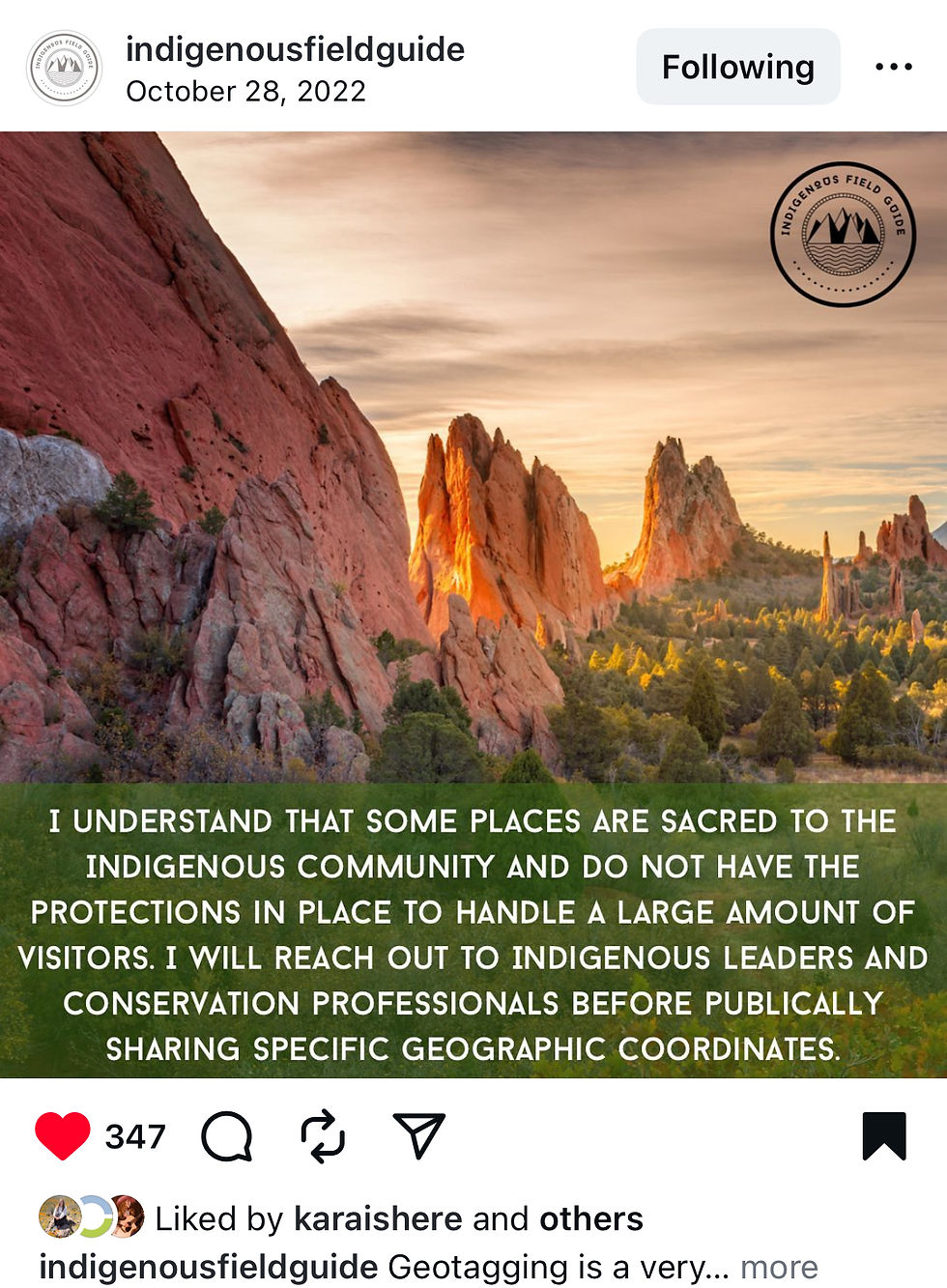
Screenshot from Indigenous Field Guide post about why Indigenous organizations ask people to not geotag
Land managers prevent this by keeping these locations unofficial, unmarked, unmapped, and unpublicized.
5. Legal Requirements Prevent Trails Leading Directly to Cultural Sites
Under federal law, including the Archaeological Resources Protection Act (ARPA) and the National Historic Preservation Act, land managers:
must protect archaeological sites
must avoid creating public access that could lead to damage
cannot expose precise locations publicly
must consult with tribal nations
must reroute trails to protect cultural features
If building a trail would increase visitation and risk, agencies are required to avoid it.
6. Protecting Cultural Resources Means Choosing Not to Build Trails
The absence of a trail is not neglect. It is intentional stewardship.
Land managers choose not to build official trails to cultural sites because the sites are fragile, and crowds would damage them. Indigenous nations request protection citing the legal frameworks that forbid exposing these places.

Bears Ears Coalition post about geotagging sacred sites in the Southwest.
Boynton Canyon Is a Perfect Example
Land managers did not build a trail to the dwelling site near the Subway Cave because the alcove architecture is unstable. They knew visitation would destroy the site. Additionally, the slope is erosive and unsafe.
Furthermore, legal and cultural protocols prohibit the route to the “Subway Cave” being an official trail and the site lacks infrastructure for sustained use. The decision to not make this an official trail was made deliberately to protect irreplaceable heritage.
Unfortunately, social media bypassed those decisions and the resulting damage was immediate, predictable, and unfortunately is permanent.
What Recreation Science Predicted And What Happened
Recreation ecology predicted exactly what would happen when visitation spikes in a fragile place.
1. Social trails exploded
Multiple braided trails now cut up the slope toward the alcove.
2. Vegetation loss accelerated erosion
Plants that once anchored soil are gone. Sediment washes out during storms.
3. Cultural resources degraded
High foot traffic, climbing, leaning, touching, and photography pressure put unsustainable stress on dwelling walls.
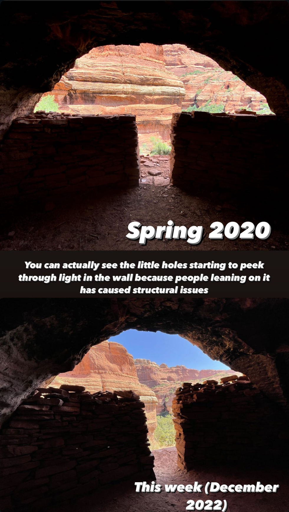
Below, top photo is before site was geotagged. Bottom photo is less than 2 years later. Visitors stacked rocks on top of the dwelling site wall damaging the structural integrity.
Myself and other stewards repeatedly begged people to stop sharing this location in fears the wall would come down.

Photo above showing 2 year difference in dwelling site walls.
4. A historic wall collapsed in 2023

As was my biggest fear, visitors knocked over the ancient wall at the dwelling site. This loss is irreversible.

The integrity of the dwelling site has permanently changed.
How To Know When You Can Responsibly Geotag A Place: The Decision Tree
Use these questions every time:
1. Is it an official trail?
Check land manager maps.
If unofficial, do not geotag.
2. Does the trailhead have bathrooms or trash cans?
If not, do not geotag.
3. Can the parking lot hold more than 15 cars?
If not, do not geotag.
4. Does the route pass through cryptobiotic soil, sensitive vegetation, or cultural sites?
If yes, do not geotag.
5. Is the feature unnamed on official maps?
If yes, do not geotag.
6. Would you be comfortable with 1,000 people visiting next weekend because of your post?
If not, do not geotag.
Why Am I Talking About This Finally
Back when people first started sharing Boynton Canyon online I tried to message influencers or bloggers begging them to take down the coordinates.
After the dwelling wall was knocked down, I tried again.

I messaged one influencer whose blog post was routinely mentioned in captions on Instagram Reels and Posts as how people found the location.


She posted on her stories that I was “rudely messaging her and harassing her”. The only messages I ever sent her are above.
She posted on her stories she was trying to get my account removed on Instagram.

People called me a gatekeeper. A “bully”. They said messages or comments (like the one above) were harassing.
I documented the damage and would message bloggers or influencers showing them the damage the geotagging was causing.
These people claimed they weren’t directing people to the dwellings but their blogs and posts said otherwise.

Redacted photo from a blog:

People made up lies about me. A group of influencers in Arizona started a smear campaign against me, got me removed from a Tourism Board trip in New Mexico (interestingly one that was visiting a Native area) which was ironic considering these influencers were mad at me for asking them to not geotag an archaeological site.
They messaged any brands or tourism boards I’d worked with spreading lies about me saying I’d harassed them. Again, the “harassment” were comments or messages like the ones shown above asking to have a conversation about geotagging dwelling or rock art sites in Sedona.
Influencers would make posts like the below, acknowledging the path wasn’t marked and you’d have to look for users paths…

And then they would go comment on people’s posts talking negatively like me. The same people above who posted about how to get to the “Subway” comment below “I’m shocked she’d take it this far.”

This far meaning, asking people to stop geotagging.
I was ostracized online. All for trying to educate about and protect these places.
You can even see, before the wall was knocked down in August 2023 I was talking about how at risk the location was for the dwelling to be be destroyed.
This story slide below includes screenshots from two reels captions “Break the Rules for the Subway Cave” and “someone laid tree branches”, that “someone” being the Forest Service.

Boynton Canyon’s Subway Cave did not become famous by accident. It became famous because a small number of individuals prioritized online popularity and profit over the land, the culture, and the fragile history inside the canyon.
Recreation ecology predicted exactly what would happen.
And now we are watching the consequences unfold: vegetation loss, braided trails, cryptobiotic soil destruction, cultural damage, safety concerns, and the collapse of a historic dwelling wall.
And I tried to prevent the destruction but people harassed me online and ostracized me. They made me out to be the “bad guy” when all I was trying to do was save this place. Think about it - what I had to gain. All I was trying to gain was saving this sacred spot. Meanwhile the people blogging about this location had ads on their blogs; more clicks equals more money. One person (me) was trying to save this sacred place while other people had financial incentives to exploit its’ location. Yet I ended up the one harassed.
I’m not sharing this for sympathy, it is a true real life case study of the impact of geotagging off trail sites and locations and is also the real story of what happened to me, a person, who simply tried to advocate for a sacred site.
If you want to learn more about any of the ecological topics discussed, I’ve compiled a list of sources below.
Thanks for reading, and remember, public lands aren’t here for recreation exclusively, they’re here to preserve sacred sites, pristine wilderness, and untouched places. We need to live in harmony with them, they aren’t a resource to exploit.
For further reading on recreation impacts, here are three published studies, below.
Cole, D. N. (2016). The Relationship Between Amount of Visitor Use and Environmental Impacts: A Contributing Paper for the Visitor Use Management Framework. National Park Service.
Monz, C. A. (2009). Sustaining Visitor Use in Protected Areas: Future Opportunities in Recreation Ecology Research and Management. U.S. Forest Service Research Paper.
https://research.fs.usda.gov/treesearch/download/34676.pdf
Leung, Y.-F. & Marion, J. L. (2000). Recreation Impacts and Management in Wilderness: A State-of-the-Knowledge Review.
https://www.umt.edu/media/wilderness/toolboxes/documents/vum/Rec%20Impacts-Mgmt.pdf


Great post. I’ve been following your Instagram account and know the amount of passion you bring.
I’m the child of a forest ranger. I remember being a grade schooler in Utah when a game ranger said that people like him who worked outdoors knew of all sorts of ancient sites that they don’t dare tell anybody about them because once word got out, people would love them to death and ruin them. That was back before gps, and social media.