.png)
The Ultimate Three Week Alps Adventure Itinerary
- Ashley Goes Hiking

- Aug 22, 2025
- 12 min read
21 Days in the Alps (Venice → Dolomites → Austria → Germany → Switzerland → Zürich)
Planning three weeks in the Alps can feel overwhelming because there are endless trails, historic cities, lakes, castles, and mountain passes to choose from.
This 21-day itinerary covers some of the best of Italy, Austria, Germany, and Switzerland in a single loop, balancing big hikes with rest days and city time.
From Venice’s canals to the Dolomites’ jagged peaks, Bavaria’s castles, and Switzerland’s panoramic ridgelines, this route gives a clear, step-by-step plan for one of Europe’s most iconic regions.
Note: This was more of a “splurge” trip so we definitely didn’t prioritize budget friendly hotels and instead opted for comfort, location, and amenities. Suggested hotels are based upon what we prioritized but each location has hotels for every budget.
Day 1 — Arrival in Venice

We kept arrival day straightforward so we could adjust to the time zone. After landing, we took a water taxi to the city. It is more expensive than the vaporetto, but it dropped us close to our hotel and cut down on luggage hauling over bridges. We checked in, got oriented with a short walk in the neighborhood, and had an early dinner.
Crowds thin in the evening, so we used the quieter hours to see a few nearby landmarks and pick up snacks and water for the next morning. Venice is compact, but walking times are deceptive because of bridges and canal detours. We planned a longer sightseeing push for Day 2.
Plan It
Stay: Hotel Antiche Figure (central, canal-side)
Arrival: Venice Marco Polo (VCE) → water taxi or vaporetto
Notes: Pack light for bridge crossings; confirm hotel check-in timing
Day 2 — Venice Sightseeing

We started before 8 am to avoid tour groups. We toured St. Mark’s Basilica, went up the Campanile for city and lagoon views, then visited the Clock Tower and the Correr Museum. Prebooking saved a lot of waiting. After a coffee stop, we walked to the Rialto area and crossed the bridge for photos.
In the afternoon we visited Libreria Acqua Alta. It is small and busy, but a quick stop is worth it if you are nearby. We built in breaks, standing at a café bar is faster and cheaper than table service. By late afternoon the main sites were crowded, so we shifted to quieter backstreets and canals.
Plan It
Stay: Hotel Antiche Figure
Sights: St. Mark’s Basilica, Campanile, Clock Tower, Correr Museum, Rialto Bridge, Libreria Acqua Alta
Tips: Modest dress for basilicas; reserve timed entries; expect slower walking speeds
Day 3 — Venice → Prosecco Hills → Ortisei (Val Gardena)
We took a water taxi to the rental office, then drove north. The Prosecco Hills are about an hour from Venice; we stopped for a tasting with a light charcuterie plate. Tastings are efficient if reserved in advance and make a good break before the mountain roads.
From Valdobbiadene we continued three hours to Ortisei in Val Gardena. The road is paved and well-signed with a few narrow sections through villages. We checked in, bought lift tickets for the next morning, and confirmed weather and operating times for Seceda and Seiser Alm.
Plan It
Stay: Hotel Angelo Engel, Ortisei
Drive: Venice → Valdobbiadene (~77 km / ~48 mi, ~1–1.5 hr) → Ortisei (~170 km / ~105 mi, ~3–3.5 hrs)
Stop: Winery tasting (reserve; many close mid-afternoon)
Prep: Check lift hours and weather the evening prior
Day 4 — Seceda and Alpe di Siusi

We rode the Ortisei–Furnes–Seceda cable cars at opening. From the top, we walked the ridgeline paths toward Pieralongia and the Odle viewpoints. Trails are signed; you can choose short out-and-backs or a longer loop depending on weather and time. Terrain is packed dirt and gravel with some short, steeper sections.
After lunch we drove to the Seiser Alm gondola for Alpe di Siusi. Walking here is easier, wide meadows, rolling grades, and several huts for coffee or strudel. We watched the time to ensure we were back at the gondola well before the last ride down.
Plan It
Stay: Hotel Angelo Engel, Ortisei
Hikes: Seceda ridgeline (easy–moderate, customizable); Alpe di Siusi meadow paths (easy)
Lifts: Ortisei–Furnes–Seceda; Seiser Alm/Alpe di Siusi gondola
Tips: Weather shifts quickly; carry a shell and sun protection
Day 5 — Drive to Misurina (Alta Via 4 base)
We checked out and drove east to Misurina. The route includes scenic passes and frequent pullouts; we limited stops to keep the day efficient. We requested a lake-view room so we could prep packs and watch the weather.
In the afternoon we laid out hut gear (cash, sleep liner, headlamp, earplugs, compact layers) and confirmed shuttle times or toll-road access for Rifugio Auronzo. We ate early and aimed for a solid sleep before the trek.
Plan It
Stay: Grand Hotel Misurina
Drive: Ortisei → Misurina ~140 km / ~87 mi (~3–3.5 hrs with brief stops)
Prep: Pack hut essentials; confirm Auronzo shuttle/toll road; check forecast
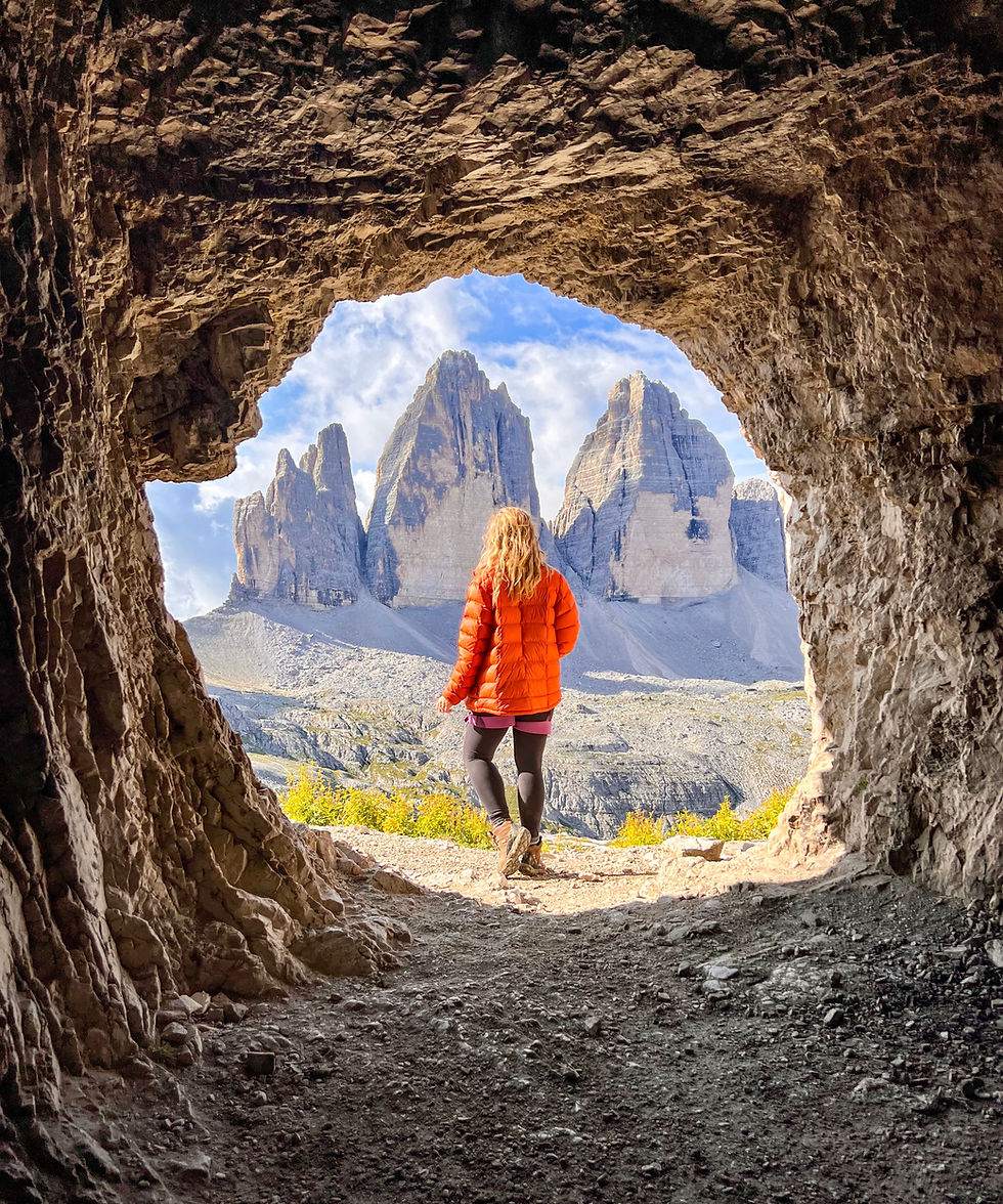
Day 6 — Alta Via 4: Misurina → Rifugio Locatelli
We used the shuttle/toll road to reach Rifugio Auronzo. The trail is a wide gravel path at first, wrapping around the southern base of Tre Cime. It takes about an hour to reach Forcella Lavaredo, where the north faces come into full view. From there, it is a steady traverse and short climb to Rifugio Locatelli.
We checked in, then had time for an optional Via Ferrata De Luca–Innerkofler to Monte Paterno. This add-on includes WWI tunnels (headlamp needed), ladders, and short exposed traverses. Parties comfortable with ferrata gear usually complete it in 2–3 hours, leaving time to return for dinner.
Plan It
Hike: ~9–12 km | ↑ 450–950 m | 5–8 hrs total (ferrata add-on increases time)
Route: Auronzo → Forcella Lavaredo → Rifugio Locatelli
Optional: VF De Luca–Innerkofler (helmet, harness, Y-lanyards, headlamp)
Tip: Book early; bring cash for meals

Day 7 — Alta Via 4: Rifugio Locatelli → Rifugio Fonda Savio
We left Locatelli toward the Cadini di Misurina. The Sentiero Bonacossa traverse begins with narrow ledges, intermittent cables, and short ladders. It is not technically long, but progress is slower due to exposure and photo stops. We paced the day with steady breaks and watched weather buildup.

Key features include the Forcella del Diavolo notch and several protected traverses. We arrived at Rifugio Fonda Savio by late afternoon, checked in, and secured dinner times. Hut amenities are basic but comfortable; expect shared dorms, set menus, and limited charging.
Plan It
Stay: Rifugio Fonda Savio
Hike: 11–13 km | ↑ ~700 m | ↓ ~850 m | 6–8 hrs
Terrain: Exposed ledges; multiple short via ferrata sections
Water/Food: Carry 1.5–2 L; hut meals in season
Day 8 — Alta Via 4: Fonda Savio → Col de Varda → Misurina → Dobbiaco
We continued the Bonacossa to the Forcella di Misurina. The pattern repeats with short climbs and descents, cables on exposed sections, and outstanding views over Lake Misurina. We reached Rifugio Col de Varda in time for a hot meal and checked lift status. If the chairlift is operating and weather is stable, it is the fastest way down; otherwise the footpath is 45–60 minutes.

Back at the lake, we walked to the car and drove to Dobbiaco. We prioritized a hotel with a good spa so we could recover from the three hut days. We also reorganized gear for the next block of hiking and city days.
Plan It
Route: Fonda Savio → Forcella di Misurina → Rifugio Col de Varda → Misurina
Hike: ~8–10 km | ↑ ~350 m | ↓ ~850 m | 5–7 hrs
Stay: Romantik Hotel Santer (Dobbiaco)
Drive: Misurina → Dobbiaco ~20 km / ~12 mi (30–40 min)
Tip: If storms threaten, minimize breaks on exposed traverses
Day 9 — Rest Day: San Candido and Dobbiaco
We scheduled a full recovery day. We used the hotel spa in the morning (saunas, pools, rest areas) and kept activity light with short walks in San Candido, coffee stops, and the Funbob alpine coaster for a quick outing.
In the afternoon we did laundry, restocked snacks, checked vehicle fluids, and confirmed the next days’ lift times and weather. A rest day like this helps reduce injury risk and keeps the trip enjoyable.
Plan It
Stay: Romantik Hotel Santer
Activities: Spa, San Candido town walk, Funbob alpine coaster
Logistics: Laundry, resupply, check lift schedules and forecasts
Day 10 — Lago di Braies and Bus de Tofana (Cortina)
We arrived at Lago di Braies at opening to secure a wooden rowboat. One hour is enough for photos and a short paddle.

After returning the boat, we drove to Cortina and started the hike to Bus de Tofana. Expect sustained ascent on rocky paths and some loose sections; trekking poles help on the descent.
The rock window provides a wide view over the Ampezzo basin. Weather and trail conditions change quickly at elevation, so we packed layers and moved off exposed terrain if clouds built. We finished the day with dinner in Cortina and an early night.
Plan It
Stay: Ambra Cortina
Drive: Dobbiaco → Braies (~20 km / ~12 mi, 30–40 min); Braies → Cortina (~48 km / ~30 mi, ~1 hr)
Hike: Bus de Tofana ~8 km | ↑ ~750 m | 4–5 hrs RT
Tip: No SUPs at Braies; boats can be reserved in time slots peak season
Day 11 — Innsbruck (Old Town + Nordkette)
We drove to Innsbruck and used the morning for Old Town, Golden Roof, City Tower, and the riverside facades. After lunch, we took the funicular and cable cars to Hafelekar on the Nordkette. Short ridge walks give strong views with minimal effort, but bring a wind layer even in summer.
Innsbruck works well as a city-and-mountain combo day. We parked in a garage near the funicular to simplify logistics and cut down walking with gear. We booked dinner near the hotel to keep the evening easy.

Plan It
Stay: NALA Individuellhotel
Drive: Cortina → Innsbruck ~160 km / ~100 mi (~3 hrs with stops)
Activities: Old Town, City Tower, Nordkette (City → Seegrube → Hafelekar)
Tip: Check last lift down times before heading up
Day 12 — Sölden and Gaislacher See
We drove an hour to Sölden and based at a hotel with a spa. We used Gaislachkoglbahn to mid-station and hiked to Gaislacher See. The route is moderate with steady grades, and the lake basin is a good spot for a break. Stronger hikers can extend to nearby viewpoints above the lake.

We planned to be back on the gondola with ample margin before last rides down. In town, we picked up snacks and water for the next morning’s drive.
Plan It
Stay: Hotel Regina, Sölden
Drive: Innsbruck → Sölden ~85 km / ~53 mi (~1–1.5 hrs)
Hike: Gaislacher See ~8 km | ↑ ~500 m | 3–4 hrs (from mid-station)
Lift: Gaislachkoglbahn
Tip: Afternoon storms are common; start by mid-morning
Day 13 — Germany: Eibsee (and optional Zugspitze)
We drove to Eibsee and walked the 7 km loop. The trail is mostly flat and well-signed with many photo stops. We rented a kayak for 30–60 minutes to access small islands and clearer water away from shore.
If time and budget allow, the Zugspitze cable car is a quick way to Germany’s highest point. Visibility varies; we checked summit cams to decide. We returned to the lake for a late lunch and a shorter second stroll.
Plan It
Stay: Eibsee Hotel
Drive: Sölden → Eibsee ~120–140 km / ~75–87 mi (2.5–3 hrs)
Activities: Eibsee loop (easy ~2 hrs), kayak rental; optional Zugspitze cable car
Tip: Arrive before 9 am on weekends/holidays to secure parking
Day 14 — Munich City Day
We drove to Munich and parked at a central garage. We started in Marienplatz to see the Glockenspiel, then climbed St. Peter’s Church tower for city views. We toured the Residenz and spent time walking the English Garden; the Eisbach river-wave surfers are worth a look.

In the evening we had a classic Bavarian dinner at a traditional beer hall. Munich works well as a one-day city stop between lake and castle days if you keep the route compact and use public transit or walk between central sights.
Plan It
Stay: Hotel Torbräu (central)
Drive: Eibsee → Munich ~100 km / ~62 mi (~1.5 hrs)
Activities: Marienplatz, St. Peter’s Tower, Residenz, English Garden, beer hall
Note: Low-emission zone; confirm rental compliance; hotel parking recommended
Day 15 — Neuschwanstein Castle
We drove to Hohenschwangau and picked up prebooked tickets. The uphill walk to Neuschwanstein is 30–40 minutes; allow buffer time for security and queues. The guided interior tour is about 35 minutes. We walked to Marienbrücke for the classic exterior view (bridge may close for maintenance or icy conditions).

We had lunch in Füssen and used the afternoon for a short town walk. Lines for shuttle buses can be long in peak season; walking down is often faster. We confirmed the next day’s cross-border drive and lodging before dinner.
Plan It
Drive: Munich → Hohenschwangau ~120 km / ~75 mi (~2 hrs)
Tickets: Reserve online; arrive early for pickup and security
Tip: Consider a quick exterior look at Hohenschwangau Castle (shorter waits)
Day 16 — Drive to Appenzell (Switzerland)
We drove about 3–3.5 hours to Appenzell, stopping once for fuel and snacks. We bought a Swiss motorway vignette if needed and confirmed parking and cable car hours for the next two hike days. Appenzell is compact with easy access to Wasserauen (Ebenalp) and Brülisau (Hoher Kasten).
In the afternoon we walked the town center, picked up picnic items, and checked weather. Summer storms can build in the Alpstein by mid-afternoon; starting hikes early helps.
Plan It
Stay: Eischen Hotel Appenzell
Drive: Hohenschwangau → Appenzell ~180–200 km / ~112–124 mi (3–3.5 hrs)
Notes: Swiss vignette required for motorways; carry CHF for rural parking/food
Day 17 — Ebenalp, Wildkirchli Caves, Äscher Hut (Schäfler option)
We drove a few minutes to Wasserauen and rode the Ebenalpbahn. From the top, the signed path descends through Wildkirchli caves and traverses to Äscher Hut. We had a meal at the hut and continued to Schäfler for a longer day. The extension adds sustained ascent and ridge exposure but rewards with wide Alpstein views.

We left enough time to return to the cable car before the last descent. Weather shifts quickly on ridges; we carried a shell, water, and snacks. Paths are popular; arriving early reduces congestion.
Plan It
Stay: Eischen Hotel
Hike: Ebenalp → Wildkirchli → Äscher → (optional) Schäfler | ~8–12 km | ↑ up to ~650 m | 3–6 hrs
Lift: Ebenalpbahn (check last down)
Tip: Trekking poles help on steeper sections
Day 18 — Hoher Kasten Panorama Trails
We drove to Brülisau and took the Hoher Kasten cable car. At the top, we walked the Geo-Weg loop. It is an easy–moderate circuit with multiple viewpoints, benches, and interpretive signs. We timed lunch at the summit restaurant and built in time for photos.

Wind is common; temperatures can be much cooler than in the valley. We carried layers and a hat and kept an eye on cloud build-up that could limit visibility. We returned mid-afternoon to rest for the next day’s longer hike.
Plan It
Stay: Eischen Hotel
Hike: Geo-Weg ~8 km | ↑ ~400 m | ~3 hrs
Day 19 — Pizol Five Lakes Hike → Bad Ragaz
We drove to Wangs in the morning and took the Pizolbahn lifts to reach the start of the Five Lakes Trail. The circuit links five alpine lakes of different colors, with steady climbs and descents along the route. Some sections can hold snow into July, so we carried poles for stability. Each lake had a distinct look, from turquoise to deep blue, and there were multiple rest spots along the way.

The hike took us about five hours including breaks. After returning on the lifts, we drove ten minutes to Bad Ragaz, a spa town known for its thermal waters. This was a good spot to rest our legs after several hiking days and enjoy a hotel with wellness facilities.
Plan It
Stay: Hotel Alpina Bad Ragaz (or Grand Resort Bad Ragaz for spa luxury)
Drive: Appenzell → Wangs/Pizolbahn ~60–70 km / ~37–43 mi (1–1.25 hrs)
Hike: ~11 km | ↑ ~600 m | ↓ ~900 m | 4–5 hrs | moderate
Lifts: Wangs → Pizolhütte (confirm lift sequence and opening dates)
Tip: Carry at least 1.5 L of water per person; shade is limited
Day 20 — Zürich City and Lake
We drove to Zürich and parked near the Old Town. We spent the morning walking through Altstadt, visiting Grossmünster and Fraumünster, and stopping at small shops along the cobbled streets. The Limmatquai riverfront made for a relaxed mid-day stroll.
In the afternoon, we headed to one of Zürich’s public swimming areas (badis) on Lake Zürich. These have lockers, showers, and diving platforms, making it easy to swim with locals and cool off in summer. For dinner, we chose a Swiss restaurant in the Old Town to keep things close to the hotel.
Plan It
Stay: Hotel Adler Zürich (Old Town)
Drive: Bad Ragaz → Zürich ~100 km / ~62 mi (1–1.5 hrs)
Activities: Old Town walk, Grossmünster, Fraumünster, Limmat riverfront, Lake Zürich swim
Tip: Some museums close on Mondays; check opening hours before planning visits
Day 21 — Fly Out of Zürich
We kept the final morning simple with breakfast and a short walk before heading to the airport. Driving directly to Zürich International Airport took about 20–30 minutes depending on traffic. If returning the car the night before, the train from Zürich HB to the airport is a fast 12-minute ride.

We arrived early to allow time for security, VAT refunds, and last-minute chocolate purchases. With gear packed and memories from four countries behind us, it was time to fly home.
Plan It
Departure: Zürich International Airport (ZRH)
Transit Option: Train from Zürich HB → ZRH ~12 minutes (if car returned early)
Notes: Double-check airline policies on hiking poles, stoves, and liquids before packing
Additional Tip:
The best way to complete this 21-day Alps itinerary is by renting a car in Venice and returning it in Zürich. Most major agencies allow one-way international rentals, though there is usually a drop fee, so it’s worth comparing companies in advance. A compact car is easiest for navigating alpine passes and tight village streets, but make sure it has enough space for luggage and gear.
Italy, Austria, Germany, and Switzerland each require you to follow local road rules, so carry your license, passport, and rental documents at all times. In Switzerland, you’ll need a motorway vignette, which can be purchased at the border if your rental car doesn’t already include one. Always check parking restrictions in cities and have coins or apps ready for meters in smaller towns. With careful planning, driving lets you cover remote valleys, reach trailheads, and enjoy scenic routes at your own pace, making it the most flexible way to explore the Alps.


Comments